Showing posts with label Maeshowe. Show all posts

Wednesday, February 19, 2020

Beowulf: The Mound and the Dragon

By Mark Patton.

In earlier blog-posts, I explored the survival of the Anglo-Saxon poem, Beowulf, and the likely contexts for the poem's performance in the mead-halls of Anglo-Saxon royal courts. Kim Rendfeld has also discussed the origins of the two monsters that the eponymous hero has to defeat in the early stages of the poem, Grendel and his terrifying mother. These early conflicts represent a rite of passage that rulers in the real world of the early Middle Ages had to go through as they came of age. Beowulf is of royal blood, but must prove himself in battle before he can take his rightful place as his father's heir: a king who could not deliver victory in battle was not a king worthy of the title at all.

In the final section of the poem, however, Beowulf is, in his own right, King of the Geats (a people who lived in part of what is now Sweden), a successful warrior and respected ruler. One might think that he had nothing more to prove, but that's not how early Medieval kingship worked: a king always had something to prove, and the final proof was that of his own mortality, something that hangs particularly heavily over Beowulf and his people, since he has no son or heir to succeed him.

Beowulf's last encounter is with a different sort of monster, a dragon:

" ... the wide kingdom reverted to Beowulf. He ruled it well
for fifty winters, grew old and wise
as warden of the land
until one began
to dominate the dark, a dragon on the prowl
from the steep vaults of a stone-roofed barrow
where he guarded a hoard; there was a hidden passage,
unknown to men, but someone managed
to enter by it and interfere
with the heathen trove. He had handled and removed
a gem-studded goblet; it gained him nothing,
though with a thief's wiles he had outwitted
the sleeping dragon; that drove him into rage,
as the people of that country would soon discover."
(Translation by Seamus Heaney).

The awakened dragon wreaks vengeance on the entire community, and, although he was not the thief, it is Beowulf's duty, as protector of his people, to deal with it, even at the cost of his own life.

The "barrow" is recognisable as a burial mound, thousands of years older than the Seventh or Eighth Century poem. Since it is in Scandinavia, it is probably a Neolithic "passage grave," built by early farming people between five and six thousand years ago, but the "long-barrows" of England and Wales are of similar antiquity and significance.

The "passage grave" of Tustrup, Denmark. Photo: Malene Thyssen (licensed under GNU).

The "long barrow" of Wayland's Smithy, Oxfordshire. Photo: Dick Bauch (licensed under CCA). Wayland the Smith is a figure from Anglo-Saxon and Nordic mythology, so the monument must have been known to the contemporaries of the Beowulf poet. 


Although the Stone Age people who built these monuments had no knowledge of metal-working, objects of bronze and gold were sometimes placed in them by later people, either as ritual offerings or for safekeeping. There are also individual burial mounds, "round barrows," built during the Bronze Age, three to four thousand years ago, both in England and Scandinavia.

"Round barrows" on the Dorset Ridgeway. Photo: Jim Champion (licensed under CCA).


For the people of the Middle Ages, prehistoric burial mounds (whether "passage graves," "long barrows," or "round barrows") were distinctive features of the landscape, places of mystery and fear, but also places where a man, if he were brave enough, might dig in search of treasure.

The Rillaton gold cup dates to the Bronze Age (1700-1500 BC), and was found in a "round barrow" in Cornwall. Photo: Fae (licensed under CCA).

The Ringlemere gold cup is of similar antiquity (it may even have been made by the same goldsmith), and was found on a site in Kent where Anglo-Saxon burial mounds sit alongside those of the Bronze Age. Photo: Dominic Coyne (licensed under CCA).


The "passage grave" of Maes Howe, on the Mainland of Orkney, provides a remarkable parallel to the story of Beowulf. The Orkneyinga Saga tells how, in the year 1153, a party of Norsemen entered the monument, and took refuge there: "On the thirteenth day of Christmas they traveled on foot over to Firth. During a snowstorm they took shelter in Maeshowe, and two of his men went insane, which slowed them down badly, so that, by the time they reached Firth, it was night time."

The "passage grave" of Maes Howe. Photo: Tim Bekaert (image is in the Public Domain).


The archaeological evidence shows that Maes Howe really was entered, on at least one occasion, by Medieval Norsemen, who carved runic inscriptions on the stone walls. Some of these are timeless and predictable graffiti: "Inigerth is the most beautiful of all women ... Thorni f****d, Helgi carved." Others, however, refer to treasure: "Crusaders broke into Maeshowe: Lif, the Earl's cook, carved these runes. To the north-west is a great treasure hidden. It was long ago that a great treasure was hidden here. Happy is he that might find that great treasure. Hakon alone bore treasure from this mound, signed, Simon Sirith."

Runic inscriptions at Maes Howe. Photo: Islandhopper (licensed under GNU).

The"dragon" of Maes Howe. Image: Islandhopper (licensed under GNU).


There is even a picture of a dragon. Was it fear of this that drove later intruders insane? Did Hakon and Simon Sirith really find treasure, or had their imaginations been ignited by an oral performance of Beowulf, or a similar poem? Might it really still have been being performed (almost certainly in another language - Old Norse, rather than Anglo-Saxon), five centuries after it was composed, and one hundred and fifty years after the only written version to have survived was placed in a monastic library? Neither history nor archaeology provide definitive answers to these questions, but fiction can travel where the historian and archaeologist cannot go.
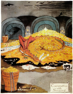
"Conversation with Smaug," by J.R.R. Tolkien ("The Hobbit"). Tolkien, who taught Anglo-Saxon at Oxford, and translated "Beowulf," drew extensively on the poem, and on the tradition to which it belongs, in his own fictional writing (image reproduced under fair usage protocols). 

[This is an Editors' Choice post, originally published on 17 August, 2017]

~~~~~~~~~~

Mark Patton blogs regularly on aspects of history and historical fiction at http://mark-patton.blogspot.co.uk. He is a published author of historical fiction and non-fiction, whose books can be purchased from Amazon.

Wednesday, March 15, 2017

Prehistoric Orkney: The People of the Lochs

By Mark Patton.

In my previous blog-posts, I looked the the earliest human colonisation of the Orkney Islands, between 4000 and 3700 BC; and at the development of small farming communities on the islands, often with communal tombs, between 3700 and 3300 BC. In this, the final posting in this series, I will focus on one specific community that flourished between 3300 and 2200 BC, around a narrow peninsula of land that separates the saltwater Loch of Stenness from the freshwater Loch of Harray, on the largest island of the archipelago (Mainland).

The Brodgar Peninsula. Photo: Jim Richardson.
The Heart of Orkney World Heritage Site. Image: Islandhopper (licensed under GNU).


When I first visited the islands, as a Cambridge undergraduate, in the winter of 1983/4, I cycled back and forth across this peninsula many times: to the north was the great stone circle of the Ring of Brodgar; to the south, the Stones of Stenness, less well-preserved, but no less impressive; and the passage grave of Maes Howe, the largest of Orkney's megalithic monuments, which reminded me of similar sites that I had seen, for example at Gavrinis and Barnenez, in Brittany, and at La Hougue Bie in Jersey.

The Ring of Brodgar. Photo: Renata (image is in the Public Domain).
The Stones of Stenness. Photo: Stevekeiretsu (licensed under CCA).
The passage grave of Maes Howe - the passage is aligned towards the Winter Solstice sunset. Photo: Rob Burke (licensed under CCA).


The concentration of these particularly impressive monuments in such a small area suggested the emergence, in the late Fourth and early Third Millennia BC, of a community on an altogether larger scale than those represented by the earlier settlements of the Knap of Howar, or Barnhouse. One of my university tutors, Professor Lord (Colin) Renfrew, who had excavated several of the islands' prehistoric sites, interpreted this as evidence for the evolution of a powerful chiefdom, and I was already beginning to formulate a similar hypothesis to explain the development of megalithic monuments in the Channel Islands.

Not far to the north of the Brodgar Peninsula, where all of these large-scale monuments are located, is the most remarkable prehistoric settlement on the Orkney Islands, the coastal village of Skara Brae. There are few trees on the Orkney Islands, but the local sandstone splits into flat slabs deal for building, so that features such as hearths, beds, and even elaborate "dressers" are preserved.

The Neolithic settlement of Skara Brae. Photo: Dg-505 (licensed under CCA).
Neolithic house at Skara Brae. Photo: John Allan (licensed under CCA).


The Australian archaeologist, Professor Gordon Childe, who had excavated Skara Brae, was a "diffusionist," who believed that most cultural change could be explained in terms of the movement of people and the spread of ideas: generally from the south and east, to the north and west. "The sole unifying theme of European prehistory," he argued, "is the irradiation of European barbarism by Oriental civilisation." Renfrew thought nothing of this theory, and neither did I, and we seemed to have the (relatively) new scientific evidence of radiocarbon dating on our side.

Professor Gordon Childe. Photo: National Library of Australia (image is in the Public Domain).


We were both unaware, however, as Childe had been before us, of what lay in the unexcavated ground beneath our feet. Over the past few years, archaeologists have been revealing the remains of an elaborate complex of stone buildings on the northern side of the Brodgar Peninsula, the site known as the Ness of Brodgar. Unlike Skara Brae, this does not seem to have been a settlement, but rather a temple complex, with many phases of construction, dismantling, and reconstruction. This seems to have come to an end in around 2200 BC, when the remaining buildings were systematically dismantled in an elaborate ceremonial, involving the slaughter of around 400 cattle.

Excavations at the Ness of Brodgar. Photo: www.orkney.com.


The people who built the Ring and Ness of Brodgar, the Stones of Stenness, and Maes Howe, clearly had connections that extended well beyond their islands. Similar stone circles appeared across much of Britain in the later Neolithic period, and people as far apart as Orkney and Wiltshire were using the same type of pottery ("grooved ware"). Passage graves comparable to Maes Howe are found in Ireland, and on Anglesey, sometimes with the same astronomical alignments.

The Rollright stone circle, Oxfordshire. Photo: Ian Freeman (licensed under CCA).
Grooved ware pottery (image is in the Public Domain).


These connections led the makers of a recent BBC documentary, "Britain's Ancient Capital - Secrets of Orkney," to conclude that the culture that gave us Stonehenge might well have originated in Orkney, but this suggested reversal of Gordon Childe's diffusionism (from west and north to south and east, rather than vice versa) seems to me to be premature: archaeologists have yet to reach or date the earliest levels at the Ness of Brodgar, and the dating evidence from stone circles across the British Isles, is patchy, at best.

The excavations at the Ness of Brodgar are among the most exciting currently in progress anywhere in the world, and there can be little doubt that much remains to be discovered.

~~~~~~~~~~

Mark Patton is a published author of historical fiction and non-fiction, whose books can be purchased from Amazon.

Wednesday, October 21, 2015

Pathways for the Sun – Britain’s Neolithic Monuments

By Lynne Kristine Thorsen

Ah, the sky. The sun signals the return of seasons. The stars provide direction. The moon is a harbinger of events, a teller of tales. We see so little of the celestial secrets today. But eons ago, the signals from the sky meant everything.

Consider the sun. With its warmth comes the seasons of planting, of fecundity. How could we, as early agronomists, know when to plant, know when the seasons would begin to change? And once we had that knowledge, how could we celebrate that change and encourage its continuation?

I started considering these questions the first time I saw Silbury Hill. It was in late June in 1991 and it was my first visit back to England in years. Silbury Hill is really quite startling. It’s obviously man-made and huge. It is part of the Avebury and Kennet Long Barrow group of Neolithic monuments. The day was drizzly and overcast, and I remember just standing and staring at the hill.


Silbury Hill

Silbury Hill is part of the neolith monuments around Avebury in Wiltshire, Britain. It is the tallest human-made prehistoric mound in Europe. Its construction dates to around 2500 BC, and calculations suggest it may have taken 500 men working for 15 years to deposit and shape the chalk and clay that it’s made from. It’s a mound. No tunnels have been found. It took technical skill and an amazing amount of labor to create this structure. It must have meant something.

Farming reached Britain around 4500 BC. It has been calculated that it took around 2000 years before farming spread across most parts of the British Isles. The advent of an agrarian society meant that people stayed pretty much where they were. They build settlements, defenses, and with agriculture, discovered new gods.

So, what does Silbury Hill look like? A mound -- a swollen belly – a pregnant earth? What could be more life-bringing than to actually see the earth as a pregnant source about to give birth to crops, to domesticated animals, to their own young. What could be a more important blessing – a visual prayer?

As crops took on a more important role so did ensuring, by whatever method they could, the best harvest. There was now time to consider how to best support this new lifestyle, how to more clearly celebrate and encourage its continuance. Something permanent and predictive was needed. Between 3200 B.C. and 2500 B.C., elaborate mounds with chambered central rooms and passageways were constructed all over Britain.

Maeshowe

Maeshowe is a Neolithic chambered cairn in the Orkney Islands. It is referred to as a burial tomb because a skull was found during early excavation. It was constructed around 2800 BC. The mound is 115 feet in diameter and rises to a height of 24 feet. There is a 45 foot long ditch that leads to the chambered mound. There is an entrance passage that is 36 feet long and leads to the central almost square chamber measuring about 15 feet on each side. The current height of the chamber is 12.5 feet high. The central chambers are built of carefully crafted slabs of flagstone weighing up to 30 tons each. Estimates of the amount of effort required to construct the cairn range from 39,000 to 100,000 man hours. That’s a lot of time.

Maeshowe Passage
Courtesy of Rob Burke
Creative Commons
Here’s the interesting bit. The mound is aligned so that the rear wall of its central chamber is illuminated during the winter solstice as the solstice sun passes down the entrance passage and into the chamber. So, not only did they have the manpower, drive, and technology to construct the cairn, they also had the calendric knowledge to allow it to serve as a signifier of the turning of the seasons, which clearly was of high significance for them.

A similar display occurs in Newgrange.

Newgrange

Newgrange is a prehistoric monument in County Meath, Ireland. It is also referred to as a passage tomb because of human bone fragments and ash that were found during the various excavations. It was built in the Neolithic period around 3200 BC, making it one of the oldest monuments of its kind. The site consists of a large circular mound with a stone passageway and interior chambers. The mound has a retaining wall at the front and is ringed by engraved kerbstones.

The mound is 249 ft across and 39 ft high. Within the mound is a chambered passage, which can be accessed by an entrance on the southeastern side of the monument. The passage stretches for 60 ft or about a third of the way into the center of the structure. At the end of the passage are three small chambers off a larger central chamber, with a high vault roof. It is estimated that it would have taken a workforce of 300 men 30 years to construct the monument.

Lit passage way during the
winter solstice at Newgrange

Courtesy of Dentp at Wikimedia
As with Maeshowe, once a year at the winter solstice, the rising sun shines directly along the long passage, illuminating the inner chamber and revealing the carvings inside, notably the spiral on the front wall of the chamber. This illumination lasts for about 17 minutes. Considerable planning and technical skill were required to construct this spectacular site.

And again, a similar observation, but this time during the summer solstice, is found at Bryn Celli Ddu on the Welsh island of Anglesey.

Bryn Celli Ddu

Maes Howe Burial Chamber
Photo courtesy of Stephen McKay
Creative Commons
Bryn Celli Ddu is a stone-chambered prehistoric monument on Anglesey in Wales. Again, it is generally referred to as a passage tomb. Bryn Celli Ddu was built with a complete passage and chamber that is buried under a mound or cairn. As it now stands, the passage is 28 ft long. The first 11 feet of the passage are not roofed. The formal entrance is flanked by a pair of portal stones.

The oldest archeological evidence from the site are ashes from postholes that date to 4000 B.C. These are thought to be the remnants of a wooden henge. Around 1000 years later, a stone henge supplanted the original wooden one. The passage monument followed, constructed around 2000 B.C.

Several unusual stones are at the site. Inside the burial chamber is a free-standing six foot high smooth stone pillar with a very rounded shape, which is quite rare.

Bryn Celli Ddu is accurately aligned to coincide with the rising sun on the longest day of the year. At dawn on midsummer solstice, shafts of light from the rising sun penetrate down the passageway to light the inner chamber. Norman Lockyer, who published the first systematic study of megalithic astronomy, was the first to notice the alignment. Later research conducted in 1997-1998 provided evidence that the site contained year-round alignments which allowed the site to be used as an agricultural calendar.

Bryn Celli Ddu
Courtesy of Wolfgang Sauber
Creative Commons

Precession of the Sun

These three separate illustrations of British Neolithic monuments designed as designators of the solstice of the seasons represent a few of the larger, more recognizable agrarian calendars. One can imagine that these sites were ceremonial, with displays and rituals to formally recognize the seasons. And one can just as easily imagine that there were many more sites with similar displays for smaller more remote communities that are no longer available. Many have been destroyed or forgotten. But some still standing may no longer function as a solar calendar.

During a full year, the sun traces a path through the stars known as the ecliptic. Anyone investigating possible architectural alignments upon the sun, moon, or planets would need to take into account the way the obliquity of the ecliptic of the sun changes over the centuries.

The last five thousand years represent a small segment of this cycle of the sun. During this time the obliquity has been gradually decreasing. One practical effect of this is that the ranges over which the rising and setting position of the sun swings during the year were somewhat wider in, say, Neolithic times. In particular, the rising and setting positions of the sun at the solstices were about one degree (two solar diameters) further away from each other then than now. In a more straightforward manner this means that smaller solstice markers would not mark the solstice today because of the difference of the position of the sun today as opposed to 5,000 years ago.

Not Burial Tombs

Significant time and effort created these monuments and many others like them. Ancient observers of the position of the sun as it related to the change of seasons knew, down to the minute, when the seasonal changes occurred. It was clearly important, extremely meaningful to their daily life, and needed to be consecrated in stone, in an immovable monument that would serve as a signifier for the ages to come.

Within and around these monuments, rituals would be performed and traditions passed down. And what could be more symbolic than a monument to the womb of the earth with a birth canal that leads out from the interior of the earth to the light of the sun. Imagine the shamans waiting inside the chamber for the solstice sun and then emerging, through the passage as if reborn, into the light of day.

It seems to be a world-wide practice among many archaeologists and laymen to label any historic puzzle that is not understood with the words, “It must have been religious.” And we tend to put our modern beliefs on top of past ritualistic sites that we don’t understand. “Oh, there are bones and ashes. It must be a tomb.” We believe in ritualistic burial, so they must have.

For me, a few bones and ashes do not turn these amazing structures into a place for the dead. It would be more appropriate to say, “Oh this was an example of their extraordinary research, science, and architecture.”

This could just be an argument about semantics. But, it illustrates a very important point, which is, as we approach the past we must discard the prejudices of the present. We need to reach back, as much as we can, and consider what their primary considerations might have been and how these considerations informed their lives and their landscape.

Sources

Ancient Astronomy, Obliquity of the ecliptic
Silbury Hill – Council for British Archeology, English Heritage, Wikipedia
Newgrange – World Heritage Ireland, Newgrange Stone Age Passage Tomb, Wikipedia
Maeshowe – Orkney’s finest chambered cairn, Wikipedia, A spectacular Neolithic chambered cairn
Bryn Celli Ddu – Cadw Welsh Government, Stones of Wales, Ancient Wisdom, Wikipedia

~~~~~~~~~~~~~

Lynn Kristine Thorsen’s two short story collections, “Fever Dreams” and “Mischief” will be published later this fall. She is also hard at work on an Elizabethan novel. She enjoys travel in Northern Wales, castles, the American Southwest, and good fiction.